Thursday, September 28, 2006

Return to campground


wr3
Originally uploaded by Brambor.

The hike to the campground and parking lot was only 2 hours. We had a great time will return again sometimes.

Wednesday, September 27, 2006

When we got to clear creek campground


smw27
Originally uploaded by Brambor.

I was totally exhausted.

The trail back was longer than yesterday


smw13
Originally uploaded by Brambor.

We stopped a few times for food or water

A new sprout


~
Originally uploaded by Brambor.

Berries along the way


smw18
Originally uploaded by Brambor.

We picked blueberries and raspberries along the way but left these berries for the birds.

Tuesday, September 26, 2006

One more along the way


~
Originally uploaded by Brambor.

Ashes


~
Originally uploaded by Brambor.

We have doused the fire and headed back towards clear creek.

By The River


~
Originally uploaded by Brambor.

Morning Flora


~
Originally uploaded by Brambor.

Monday, September 25, 2006

Morning at Three Forks


smw19
Originally uploaded by Brambor.

Morning at Three Forks


~
Originally uploaded by Brambor.

Morning observations at Three Forks


sm0007
Originally uploaded by Brambor.

Three Forks Park in the Morning


~
Originally uploaded by Brambor.

The next morning showed frost on the grass. The boys were still sleeping so I went around to take some photographs.

Friday, September 15, 2006

Three Forks Park Camp


~
Originally uploaded by Brambor.

We camped at Three Forks for the night.

Green River


~
Originally uploaded by Brambor.

The color of the Green River is phenomenal. The glacial runoff dust makes the color almost turquoise.

Green River Crossing


smw25
Originally uploaded by Brambor.

As we crossed the Green River we took a break and cooked lunch on the straight steps of the wooden bridge.

Wonderful Trail


smw31
Originally uploaded by Brambor.

The weather cooperated and the trail varied to keep things interesting.

On towards three forks


wr11
Originally uploaded by Brambor.

The next morning we packed up and headed towards Three Forks Park.

Thursday, September 14, 2006

Across the Green River


~
Originally uploaded by Brambor.

As we were falling asleep we heard a lonely coyote's barking from across the river. The sounds were eerily echoing through the valley.

Green River and Squaretop Mountain


Green River and Squaretop Mountain
Originally uploaded by Brambor.

We camped near the river on a nice outcroping overlooking the whole valley. As the dusk approached I went down to the river banks to take some photos.

Wednesday, September 13, 2006

Dagen and Trevor crossing Clear Creek


Dagen and Trevor crossing Clear Creek
Originally uploaded by Brambor.

Map 1

We will take the Highline Trail along the northern side of the lake.

Highline Trail


Highline Trail
Originally uploaded by Brambor.

My son Dagen is approaching water crossing to join the Highline Trail

Green River Campground Trailhead


Green River Campground Trailhead
Originally uploaded by Brambor.

I'm back. This time to hike the Green River watershed. This time I've taken Trevor (pictured) and Dagen. My two sons.

Monday, August 14, 2006

Day 13 Green River Lakes


Image151
Originally uploaded by Brambor.

DAY 13. The next day I visited Green River Lakes in rented car. Here is where I should have been 3 days from now had my shoe not disintegrated. This was the end of my hike. I wanted to come back and complete this trip someday.

Closer to Elkhart Pass


Image150
Originally uploaded by Brambor.

DAY 12., It was a trying day hiking with badly chafed legs and a boot that was separated from the sole. I slept over night near Mary's Lake. The next day I tried to take my left sneaker and put the left boot on my right foot. I only put my liner sock on and it felt much better than hiking with the roped concoction. I made a better way down toward the trailhead. It still took me about 5 hours of hiking from here. At the trailhead I hitched a ride to Pinedale where I took a shower, attended to my scrapes and bought new shoes.

Hat Pass


Image146
Originally uploaded by Brambor.

Elevation 10,648. I finally reached Hat Pass. The hike from Pipestone Lakes up to here was a tough way to finish up the day hike. I camped about 200 feet below the peak.

Sunset at Hat Pass camp.

Pipestone Lake


Image143
Originally uploaded by Brambor.

Pipestone Lake. At this point my right boot was totally falling apart. I stopped here to fish for fine cutthroats I've seen cruising along the shore. Along came a hiker who encouraged me to be positive about my boot. He was wearing New Balance sneakers and was through hiking CDT from Canada to Mexico.

One of the nice Cutthroats out of Pipestone Lake. I think I caught about 6 fish and moved on. This picture taken with the fish on the line, my fishing rod under my armpit and camera in my hands.

To Halls Butte


Image139
Originally uploaded by Brambor.

I witnessed a lot of fire damage on my way to Halls Butte. This section probably experienced recent fires.

Day 10 - Sandpoint Lake


Image137
Originally uploaded by Brambor.

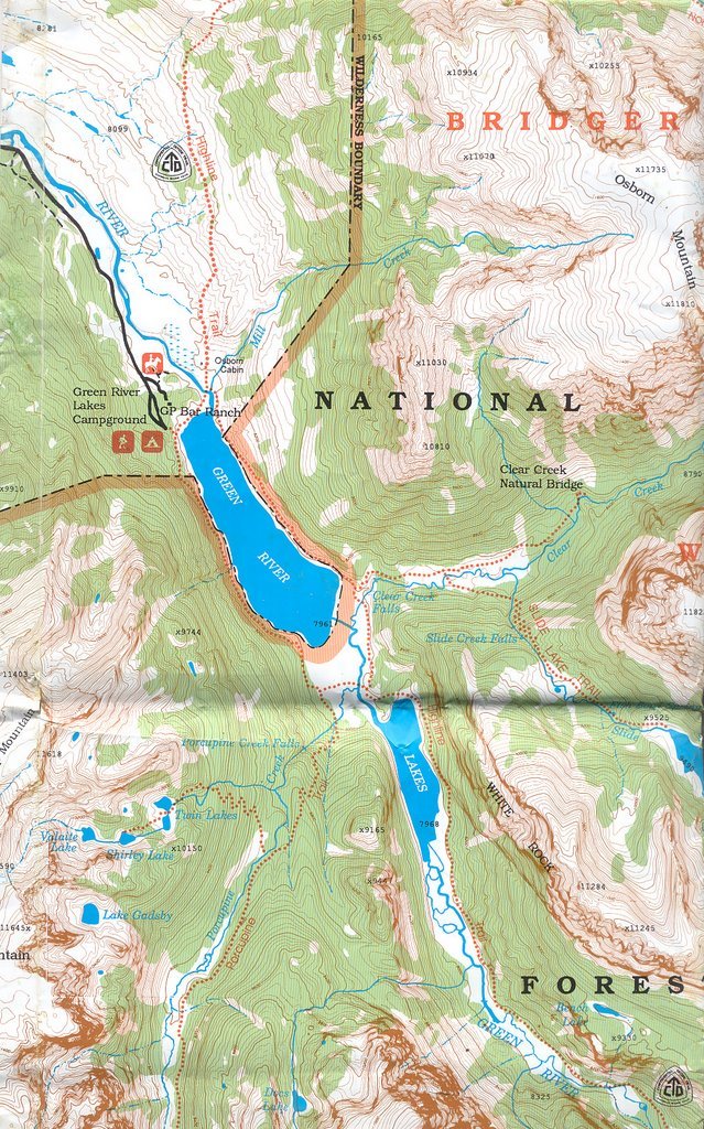
Elevation 9810 feet.The hike from Bonneville's to Sandpoint Lake was mostly flat. Sandpoint lake had a small sandy beach. I took a plunge and had a refreshing swim.

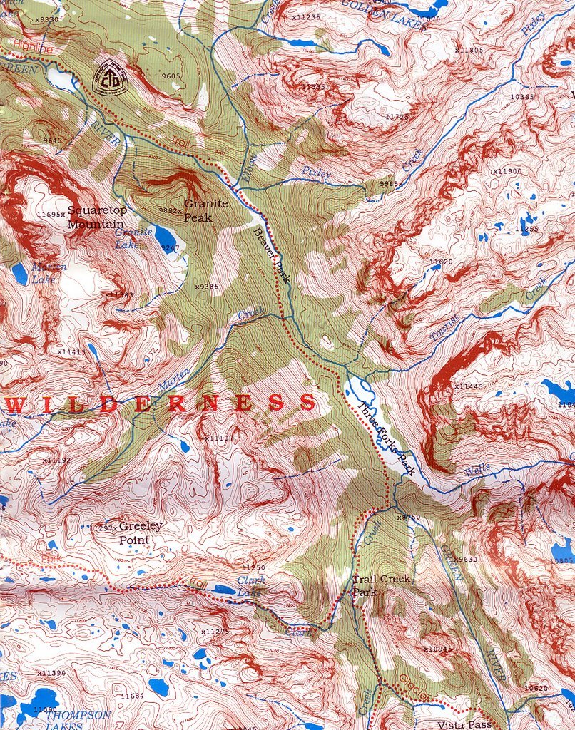
The issue now became my boot. The sole fell completely apart. I tried to use utility rope to tie it back together but after a mile or so it broke again. I realized that I will not complete my hike to Titcomb lakes and to Green River Lake. I had to come down to a trailhead for repairs. This still meant 2 days of hiking. I was in for 2 long days.

Saturday, August 12, 2006

Elevation 10, 828 feet


Image131
Originally uploaded by Brambor.

Elevation 10,828 feet. Large Bonnevile Lake. It was still worth coming up here. I fished the water for about 30 minutes and saw absolutely nothing. I wonder if there is any fish in this lake. Whenever I thouthgt a lake is too high I got surprised by looking at the map. There is another body of water draining into this lake called Sheila Lake at elevation 11,015 feet.

Bonneville Lakes


Image130
Originally uploaded by Brambor.

Here is a look from the top of Bonneville Lake towards small Bonneville lake. Earlier today I passed the end of little Bonneville lake and instead of continuing along the shore I ascended the left side towards Bonneville peak.

Cliffing


Image128
Originally uploaded by Brambor.

The cliff was very steep. I wasn't sure I wanted to do it with my backpack on. After a careful study I saw a potential route. I made the decision to go risk it.

About halfway of careful rock hopping I ran into a dead end. This view is basically looking straight down of what I had to complete. I got to a point that was not visible from previous vantage point when I thought I had a route. I did another study of the terrain and found that ascending about a hundred feet to the left and then choosing another way down might be possible.

Bonneville Lake


Image126
Originally uploaded by Brambor.

First glimpse of Bonneville lake. I thought that I might be able to scale the cliff down to the lake.

Looking for a lake


Image125
Originally uploaded by Brambor.

Temporarily Lost


Image124
Originally uploaded by Brambor.

When I got to the top I realized I made a huge error reading the map. It happens that the map ended on one side and when I flipped it over I asumed the lakes to be more to my left when in fact the lakes were duplicated on the other side. So I passed small Bonneville lake already and instead of just following the water up I turned left and ended up almost at the top of Mt. Bonneville near a nice spring.

Bonneville peak. I was lost. Probably around 11,400 feet and about 1000 feet from Bonneville Peak. I did not want to go back down. I decided to scale the left side to get a glimpse of the Bonneville lake.

Day 9


Image122
Originally uploaded by Brambor.

The next day I headed to find the Bonneville Lakes. Looking at the map I chose a route to my right. There was no trail so I followed faint outlines of trail that was probably made by elk.

When I reached the top of the first mountain I was puzzled I couldn't see the Bonneville lakes. I chose the next peak to my left and kept on ascending.

Bonneville Basin


Image119
Originally uploaded by Brambor.

I hiked all day through a lot of expansive plains until I reached the mountains with Bonneville Lakes. From there on the trail climbed steeply up. My boot did not look good. I tried to favor my other foot a little bit as not to damage the sole any further.

It seems that every day I finished totally exhausted. I reached Bonnevile basin in the evening, lay in the tent for an hour just recuperating. Then I cooked dinner and fished for a while. I caught lots of 12 inch brookies here. Some of them were picky but a well placed fly next to a boulder would trigger a bite. The basin elevation is about 11,000 feet. There were few mornings where I had to take frost off my tent. The frost on the tent is slightly visible in this picture. Picture was taken early morning on day 9.

Day 8 - On towards Boneville Lakes


Image108
Originally uploaded by Brambor.

The next day I headed towards Bonneville lakes. That morning I discovered I lost my right sneaker during yesterday's hike. I also discovered that my hiking boot soles came unglued.

Thursday, August 10, 2006

Back at Washakie Creek


Image107
Originally uploaded by Brambor.

I hiked all day, crossing Hailey Pass, back to Pyramid Lake and to Washakie Creek. I followed the creek downstream for a while until I found a suitable camp near the trail. This is the view from my camp. I fished this portion of Washakie creek after dinner. It was full of small 10 inch brookies. They were very easy to catch. I caught about 10 and headed back to my tent.

Top of Hailey Pass


Image101
Originally uploaded by Brambor.

Elevation 11,600 feet. The hike to Hailey's pass was very steep. I was surprised that immediately at the top of the pass I saw two beautiful alpine ponds called Twin Lakes. I sat on the left shore and while I rested and resuplied water I was scanning the surface for signs of fish. I did not see any activity so I elected to continue my hike.

Day 7


Image097
Originally uploaded by Brambor.

DAY 7. The next day I headed back down to cross the Hailey's Pass. I had to hike almost back to Grave Lake. The trail to Hailey Pass split above the waterfall I crossed yesterday.

Wednesday, August 09, 2006

Baptiste Lake Sunset


Image093
Originally uploaded by Brambor.

After the sunset I hiked back to my tent and enjoyed a good night sleep.

Sunset


Image095
Originally uploaded by Brambor.

The photographs for this sunset have not been enhanced. The evening was truly magical.

Sunset


Image096
Originally uploaded by Brambor.

I spent the rest of the day fishing for large cuttthroats until a huge thunderstorm chased me into the tent. The rain was strong and I noticed a few seams lose their repelency. The skies after the thunderstorm were magical. I grabbed the camera and the fishing rod and spent the rest of the light photographing and fishing.

Tuesday, August 08, 2006

Baptiste Lake Cutthroat


Image089
Originally uploaded by Brambor.

The wind was present but when I showed up at the shore to fish the conditions became ideal for about 10 minutes. I could see into the water and couldn't believe my eyes. Huge football trout were cruising the shores looking for food. This rainbow did not want to eat my Royal Coachman until I cast it just to the side of his head when he instinctively turned and snatched the fly.

Baptiste Lake


Image088
Originally uploaded by Brambor.

I made it to the lake by 1PM. I decided to break camp and enjoy this place. The ice was still melting into the lake and fish was seen cruising everywhere.

basin


Image083
Originally uploaded by Brambor.

The hike was not strenuous. I was close to the Baptiste lake. It was somewhere beyond the hill. The trouble was that the trail disappeared completely. I checked the map many times before I headed up the cliffs.

Wildflowers


Image081
Originally uploaded by Brambor.

The trail was faint and disappeared in places. Since the Baptiste lake was a dead end trail it appeared that it did not get travelled often. The smell of pine and wildflowers filled the air.